Trail Winter sports Neyruz (FR) - Gibloux - Photo
 remo
remo

User

© OpenStreetMap contributors
Length
Length
40 km
Max alt
Max alt
1229 m
Uphill gradient
Uphill gradient
1108 m
Km-Effort
Km-Effort  
55 km
Min alt
Min alt
607 m
Downhill gradient
Downhill gradient
1101 m
Boucle
Boucle
Yes
Creation date :
2014-12-11 00:00:00.0
Updated on :
2014-12-11 00:00:00.0

(0 Reviews)

Winter sports
Winter sports
--
Difficulty : Unknown

Scan this QR Code to open this trail in the SityTrail application

FREE GPS app for hiking

Logo SityTrail SityTrail

IGN / Geographical institutes

Download SityTrail from the App Store Download SityTrail from Google Play

Logo SityTrail SityTrail World

The world is yours!

Download SityTrail from the App Store Download SityTrail from Google Play Download SityTrail on Huawei AppGallery

About

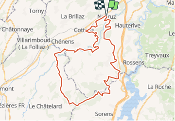
Trail Winter sports of 40 km to be discovered at Fribourg, Sarine District, Neyruz (FR). This trail is proposed by remo.

Description

Der Gibloux ist ein vorgelagerter Hügel vor dem Lac de la Gruyère. Seine wunderschöne Rundsicht entschädigt für den Aufstieg. Der Weg dorthin ist einzigartig. Der Abstieg erfodert Ausdauer und eine gewisse technische Erfahrung mit dem MTB.

Hinweis: Die Trackdaten können auf http://www.remosworld.ch gratis gedownloadet werden.

Elevation profile

Positioning

Country:
Switzerland
Region :
Fribourg
Department/Province :
Sarine District
Municipality :
Neyruz (FR)
Location:
Unknown
Start:(UTM)
352232 ; 5180977 (32T) N.

Trails nearby

Trail On foot Villars-sur-Glâne - Tour des trois rivières - Photo
On foot
GUIDE+

On foot

Easy
Villars-sur-Glâne, Fribourg, Sarine District, Switzerland
5.1 km | 7.1 km-effort
1h 36min
No
Trail On foot Hauterive (FR) - Circuit Hauterive - Photo
On foot
GUIDE+

On foot

Easy
Hauterive (FR), Fribourg, Sarine District, Switzerland
5 km | 6.7 km-effort
1h 31min
No
Trail On foot Hauterive (FR) - Hauterive - La Tuffière - Photo
On foot
GUIDE+

On foot

Easy
Hauterive (FR), Fribourg, Sarine District, Switzerland
5 km | 6.6 km-effort
1h 30min
No
Trail On foot Matran - Matran - Noréaz - Photo
On foot
GUIDE+

On foot

Easy
Matran, Fribourg, Sarine District, Switzerland
5.9 km | 7.2 km-effort
1h 38min
No
Trail On foot Hauterive (FR) - Circuit de La Tuffière - Photo
On foot
GUIDE+

On foot

Easy
Hauterive (FR), Fribourg, Sarine District, Switzerland
6.2 km | 8.2 km-effort
1h 52min
No
Trail On foot Hauterive (FR) - Grangeneuve - La Tuffière - Photo
On foot
GUIDE+

On foot

Easy
Hauterive (FR), Fribourg, Sarine District, Switzerland
5 km | 6.6 km-effort
1h 29min
No
Trail On foot Hauterive (FR) - Monterban - La Glâne - Photo
On foot
GUIDE+

On foot

Easy
Hauterive (FR), Fribourg, Sarine District, Switzerland
3.2 km | 3.7 km-effort
50min
No
Trail On foot Corminboeuf - Corminboeuf Village Suisse - Matran - Photo
On foot
GUIDE+

On foot

Easy
Corminboeuf, Fribourg, Sarine District, Switzerland
3.2 km | 4.1 km-effort
55min
No
Trail On foot Treyvaux - Circuit de la Combert par le sommet - Photo
On foot
GUIDE+

On foot

Easy
Treyvaux, Fribourg, Sarine District, Switzerland
7.4 km | 12.2 km-effort
2h 46min
No


Close
My subscriptions